
Executive Operational Telemetry: High-Altitude Plunge Overview
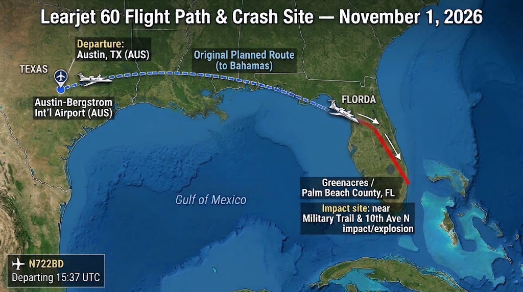
On November 1, 2026, a Bombardier Learjet 60 operating from Austin-Bergstrom International Airport (AUS) to North Eleuthera Airport (ELH) suffered an uncontrolled vertical dive over southeastern Florida:
- Flight Upset: Transiting near FL350, the crew reported turbulence and light icing, quickly escalating to a Mayday with extreme vertical descent rates (climbing from 10,000 fpm to ~20,000 fpm).
- Catastrophic Drop: Radar data recorded a drop of 26,500 feet (from 35,250 ft to 8,750 ft) in approximately 60 to 65 seconds before radar signal loss.
- Casualties: U.S. Transportation Secretary Sean Duffy confirmed 9 fatalities (all occupants aboard). No ground injuries or fatalities occurred in the Greenacres residential area.
- Lead Probe: The National Transportation Safety Board (NTSB) has assumed lead investigative status, prioritizing black box recovery, aerodynamic trim audits, and atmospheric reconstruction.
1. The Flight and Incident Overview
The Bombardier Learjet 60 departed Austin-Bergstrom International Airport (AUS) bound for North Eleuthera Airport (ELH) in the Bahamas. At approximately 12:50 p.m. local time, the aircraft plunged into an open area near Military Trail, between Cresthaven Boulevard and 10th Avenue North, in the Greenacres community of Palm Beach County, Florida.
The impact produced a significant crater and post-crash fire, scattering debris near residential structures and a mobile home neighborhood. Transportation Secretary Sean Duffy confirmed that all nine occupants aboard were killed. Local officials reported no ground fatalities or injuries, though nearby residents were evacuated while hazardous materials and fire teams stabilized the perimeter.

2. Final Minutes: The Descent Timeline
Air traffic control (ATC) recordings document a rapid transition from routine route adjustments to an uncontrolled emergency:
3. Fuel Load and Consumption Estimates
A Learjet 60 holds approximately 1,185 US gallons of fuel (7,910 lb). Based on the flight duration of roughly 2 hours and 13 minutes and a typical fuel burn rate of 219–235 gallons per hour, the jet would have consumed an estimated 500 gallons prior to the crash, leaving roughly 685 gallons on board at the time of impact.
However, because the actual takeoff fuel load has not yet been officially established by investigators, this remaining figure remains a hypothetical calculation subject to specific flight conditions and routing details.
4. Fact-Check: Calculating the Descent Rate
Multiple claims and velocity estimates have circulated regarding the physics of the aircraft's final plunge. The difference between 35,250 feet and 8,750 feet represents an altitude drop of 26,500 feet (approximately 5.02 statute miles).
Vertical velocity calculations over the final drop intervals show:
(26,500 ft / 60 s) × (3,600 s/hr) / (5,280 ft/mi) = 301.14 mph
(26,500 ft / 65 s) × (3,600 s/hr) / (5,280 ft/mi) = 277.97 mph
The mathematical calculations reflect the average vertical descent speed during that specific phase of flight. However, this does not represent the aircraft's true airspeed or total velocity through the air, which combines vertical descent with forward horizontal trajectory.
5. Active Inquiry vs. Misinformation
| Reported Claim | Status | Factual Context |
|---|---|---|
| Shootdown / External Sabotage | Unsubstantiated | Online speculation claiming hostile or intentional ground fire lacks any corroborating evidence from radar, ATC transcripts, or law enforcement. |
| Weather as Definitive Cause | Premature | Reports of icing, convective turbulence, and precipitation were logged by the crew, but the NTSB has not established whether weather caused a structural failure, control upset, or sensor issue. |
| Ground Casualties | Unconfirmed / None Reported | Early confusion arose over structural damage near homes, but emergency officials confirmed zero fatalities or serious injuries among residents on the ground. |
6. The Investigation Ahead
The National Transportation Safety Board (NTSB) has assumed lead agency status, supported by technical specialists from the FAA and the airframe/engine manufacturers. Key areas of focus include:
A preliminary report from the NTSB is expected within 30 days of the on-site examination.
7. Aircraft Technical Specifications
| Specification | Metric / Detail |
|---|---|
| Aircraft Model | Learjet 60 |
| Category | Midsize Business Jet |
| Standard Crew | 2 pilots |
| Passenger Capacity | 6–8 (layout dependent) |
| Powerplant | 2 × Pratt & Whitney Canada PW305A turbofans |
| Thrust Rating | 4,600 lbf per engine |
| Length / Wingspan | 58 ft 8 in (17.88 m) / 43 ft 9 in (13.34 m) |
| Maximum Takeoff Weight (MTOW) | 23,500 lb (10,659 kg) |
| Normal Cruise Speed | 460–465 KTAS |
| Maximum Operating Ceiling | 51,000 ft |
| Operational Range | ~2,180–2,405 NM |
Cross-Desk Telemetry Integration
Correlated against FAA primary and secondary surveillance radar logs, Miami ARTCC Sector 64 audio frequency recordings, ADS-B telemetry records, and National Weather Service Doppler radar scans over southeastern Florida.